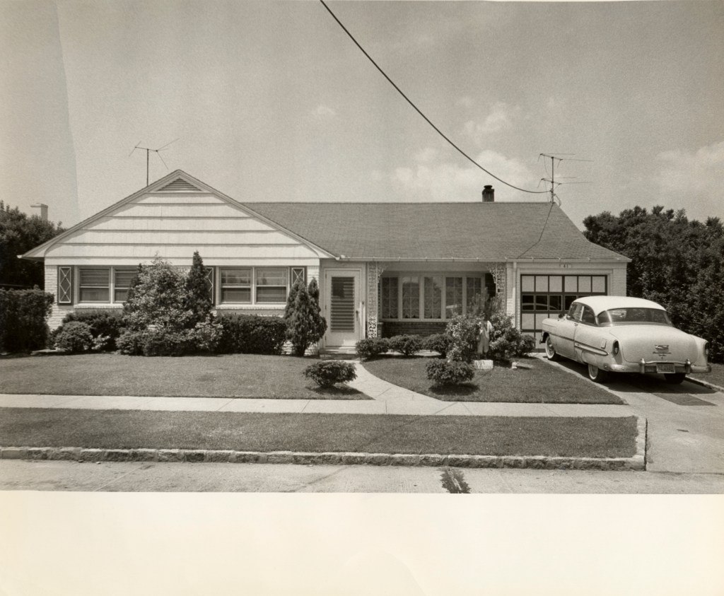
I recently did some research on my neighborhood. The homes were all built by 1960 and all seem to appear similar. This is not unlike many parts of the San Fernando Valley.
I took to the Los Angeles Department of Building and Safety’s “search building records”, and found who my home’s developer was. I did some research on the developer and ended up finding out there was a name for my little pocket neighborhood.
The housing boom was from 1950s to early 1970s. The West San Fernando Valley was prime real estate for suburban sprawl. Many ranches were being converted to housing developments and tract homes built by enterprising developers. The neighborhoods may not have their original names attached to the walls surrounding them, so if I found out mine, what were the neighboring homes? You’ll find from reading my posts I’m curious about odd things.
Here’s a timeline for context.
The 1930s in the San Fernando Valley:
“The valley’s overall land use pattern had three outstanding aspects: field crops, fruit and nuts, and dairy and poultry raising. Field crops such as alfalfa and beans, plus miscellaneous truck products, were dominant really and were concentrated in the central and west valley. Citrus holdings were concentrated in the north and northeast, with· lesser plantings in the west. Most groves were situated on relatively frost-free ground, were owner-operated,· and consisted of tracts of 10 to 15 acres. North of San Fernando considerable acreage was devoted to olives, deciduous fruit and walnut trees were distributed over the valley floor, and poultry raising and dairy farming were concentrated in the west.”
RICHARD E. PRESTON (THE CHANGING LANDSCAPE OF THE
SAN FERNANDO VALLEY
BETvVEEN 1930 AND 1964)
The 1940s in the San Fernando Valley:
“By 1940 the population of the San Fernando Valley had increased to 155,443, an addition of approximately 77,000 since 1930. Even so, the pattern of settlement and land utilization was basically the same as in the early 1930’s (Figures 3 and 4). The greatest area of change was the southeast, where the once-independent urban nuclei were beginning to coalesce, and where significant development was beginning to project westward along major streets. Although settlement thinned-out rapidly toward the west, the new communities located there were nevertheless attracting population, especially Canoga Park, Reseda, and Tarzana.”
RICHARD E. PRESTON (THE CHANGING LANDSCAPE OF THE
SAN FERNANDO VALLEY
BETvVEEN 1930 AND 1964)
By the 1950s:
By 1950 the tide of urban land use, consisting mostly of tract houses and commercial string-development had moved westward halfway across the valley floor (Figures 5 and 6). In addition to this westward and north ward spread, subdivision was taking place. actively on ·the periphery of the urban nuclei in the west.
RICHARD E. PRESTON (THE CHANGING LANDSCAPE OF THE
SAN FERNANDO VALLEY
BETvVEEN 1930 AND 1964)
Finally by the 1960s:
Valley population was 840,500 in 1960, an increase of approximately 438,000 over 1950. During the same period the overall population density rose from 2.7 per acre to 5.6.8 Highest densities were associated with the older built-up areas in the southeast where extensive apartment construc tion was taking place. In general, however, home-building was continuing to spread like a wave from east to west, cutting into the remaining agricultural and vacant lands on the periphery, into the hills, and· into the vacant enclaves.
RICHARD E. PRESTON (THE CHANGING LANDSCAPE OF THE
SAN FERNANDO VALLEY
BETvVEEN 1930 AND 1964)
I also found a wealth of information from Tract Housing in California, 1945-1973 if you want another in depth account.
If you know the name of your the developer/builder, I can search for this for you. Just let me know in the comments below and I’ll update this post with more info.
Canoga Hermosa (East of Shoup and South of Vanowen)

Randi Park (West of Topanga and South of Vanowen)
 Randi Park (Topanga and Vanowen) 1954 Fri, Jun 18, 1954 – 6 · Valley Times (North Hollywood, California) · Newspapers.com
Harmony Terrace (East of Capistrano, North of Roscoe)

Sun Ray Estates Canoga Gardens (East of Royer, North of Saticoy)

Adlon’s s Canoga Plaza (East of Fallbrook, South Sherman Way)

George Ponty’s Triumph Estates (East of Shoup near Kittridge)

George Ponty’s Triumph Estates Canoga Park 1959 Sun, Mar 15, 1959 – 132 · The Los Angeles Times (Los Angeles, California) · Newspapers.com
Van-Owen Estates off Shoup (East of Shoup and North of Vanowen)

Canoga Ranchos (Topanga and Saticoy and Topanga and Sherman Way?)

Valley Park Highlands (Vanowen and Shoup)

Park Terrace (Fallbrook and Roscoe)

Countryside Homes (West of Fallbrook and North of Sherman Way)

Walnut Grove (West of Mason and North of Roscoe)

Scoop? (Saticoy and Variel)

Tampa Country Estates (Victory and Tampa)

Valley View Riviera (Topanga and Parthenia)

Cinderella Square (Topanga and Roscoe)

Westridge Estates (De Soto & Roscoe)
 Westridge Estates 1958 Sun, Mar 9, 1958 – 108 · The Los Angeles Times (Los Angeles, California) · Newspapers.com
Royal Knolls (Burbank and Fallbrook)
 Royal Knolls 1958 Sun, Jul 13, 1958 – 116 · The Los Angeles Times (Los Angeles, California) · Newspapers.com
Sunkist Gardens (Shoup and Ventura Blvd)

Valley Circle Estates (Valley Circle and Calvert)

Bart Fenmore Homes (Oso and Sherman Way)
 BURT FENMORE HOMES 1965 Sun, Dec 12, 1965 – 174 · The Los Angeles Times (Los Angeles, California) · Newspapers.com
Woodland Oaks (Mulholland and Canoga)


Leave a comment